Innovating wildlife conservation, one drone flight at a time

Colorado is enormous. At nearly 105,000 square miles, the 38th state is roughly the size of New Zealand or Ecuador, a vast expanse of plains, mountains, canyons, rivers and more. Traditionally, wildlife conservation work here has been a herculean task, requiring a vast amount of people deployed in the field. But what if there were another way?
In 2013, Gustavo Lozada had an idea.
Eye in the sky
The technology operations manager at the Colorado branch of The Nature Conservancy (TNC) grew up in Venezuela, fascinated by radio-controlled helicopters. As he got older, his interest in all things aerial led him to the emerging world of drones.
Working with TNC, he helped count bison populations, assess damage from wildfires, identify cottonwood trees, and do other painstaking work on foot. “That’s when it occurred to me,” Lozada says. “I knew drones could be the answer.”

So Lozada set off to establish a pilot program using drones in the wild—creating a relatively cheap and effective way to map difficult-to-reach areas. “We took footage from our preserve at the Zapata Ranch in Southern Colorado, where there are hundreds of bison,” he says. “Keeping an inventory of the herd in the preserve is really important so we can understand how the population is changing.”
Previously, the crew had to drive four-wheel vehicles around the 50,000-acre property, often getting stuck in the muddy terrain. “But with drones,” Lozada says, “we were able to track and count the bison without driving anywhere.”
Surprised and pleased, Lozada’s superiors gave him approval to look for other ways to use drone technology. He found them easily.

One drone, several cameras
Drones are evolving quickly, as are the cameras and sensors they carry, increasing their value for conservationists. By attaching different cameras for different purposes, Lozada is able to collect infrared data and nocturnal activity. For example, the Colorado TNC is tasked with counting and tracking the bobolink, a migratory blackbird. Traditionally, this has been a difficult project. “It’s almost impossible to count the nest of that bird without disturbing the hayfield they live in or creating a path for other predators to reach the nest,” Lozada says. But the heat signature of the nest is very particular, so using a drone with a thermal camera allows Lozada to look for those unique heat signatures and count the nests. Safe, easy, effective.

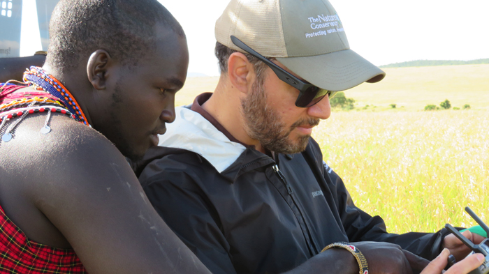
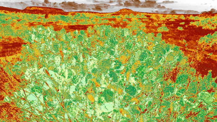
Lozada’s work, however, extends beyond the borders of Colorado. He’s working on a project at the Loisaba Conservancy in Kenya using drones to map the spread of the invasive Opuntia cactus, or prickly pear. The plant, native to North America, is aggressive, increasing its coverage by up to a third every year. It can also be dangerous, as the thorns can damage the throat of a baby elephant and other animals who eat it. But with the help of drone-created maps, officials at the 56,000-acre community-conservation project can help stop the Opuntia’s spread. Armed with this data, they can determine where the spread might go next and stop it before it does.

How to hover over a herd—without starting a stampede
While drones can help with mapping and allow people to observe animals in their natural habitat, they can also present dangers if not used properly. Lozada points to some nature documentaries that show incredible footage of animals running.
What the viewer may not realize, however, is that the animals might be running because they are scared of the sound the drone makes. This creates a dangerous situation where fleeing animals can run themselves to exhaustion or injure themselves. “Much of the wildlife drone footage you find online, especially in Africa with big mammals, is the animal running hard,” he says. “And that footage might be amazing, but it’s bad for the wildlife.”

Lozada takes a different approach to wildlife conservation, trying to help the animals get used to the drones, gently and slowly. He tested his theory on a group of elephants in Africa, hovering miles away and slowly inching closer. The tactic required immense patience, but it paid off. “I was able to film them in their natural behavior, undisrupted,” he says. “That was impressive. The park rangers were almost crying, telling me, ‘This is game changer for us.’”

A necessary connection
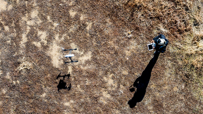
Lozada believes that responsible drone use will only be a net positive for the scientific community. Of course, staying connected is a vital part of success when it comes to using drones. “We map in very remote reserves. Let’s say we want to map 20 acres of a forest,” Lozada says. “The drones start taking photos every second, then come back with a thousand images. You have to upload the images quickly and get them to the cloud to start processing the data. The cloud servers start stitching the images together to create a high-resolution map. And three to five hours later, I get back a whole map. And in the field, I download the map and start analyzing the data.
“The last thing you want is to drive four hours into a preserve, map, then come back and realize that your mapping is not what you wanted,” Lozada says. “Without a robust connection, none of this is possible.”

A modern-day Johnny Appleseed
In the future, Lozada only sees more uses for the drone program in wildlife conservation. For example, a drone could fly into the middle of a lake and take a water sample, allowing scientists to more accurately understand what’s in the water without the disturbance that a boat would create. Some groups use drones for emergency search and rescue with seals and sea turtles. An arm of The Nature Conservancy in the Caribbean is working to develop a drone that’s protected from salt water, which would increase the potential use cases. Drones will even play a proactive role in helping to improve the environment. Lozada knows of experiments where fleets of drones are programmed to drop pellets with tree seeds and nutrients to help the seed survive. While the technique hasn’t been mastered yet, the pilot programs are underway, and this force of modern-day Johnny Appleseed drones is coming.
“We need some time to perfect the technology, but it’s coming for sure,” Lozada says. “And I love it.”
See how Verizon is helping to put drones to work in new ways and innovating the future fueled with the power of 5G.